
By Open Chronicle Explained
Open a map on your phone and a small blue dot appears.
It may show which street you are standing on, which direction you are travelling and how far you are from your destination.
A car navigation system can do the same thing.
So can an aircraft, ship, surveying instrument or agricultural machine.
It feels as though something in space must be watching every receiver below.
That is not how GPS works.
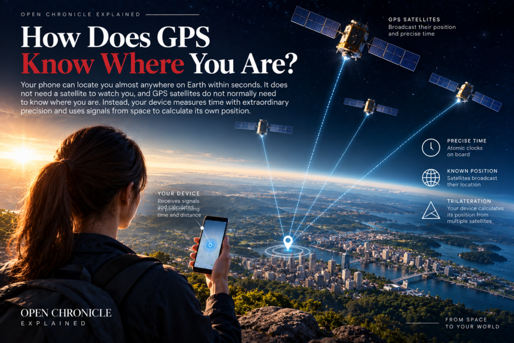
The satellites are essentially broadcasting extremely precise information about time and their own positions.
Your receiver listens.
Then mathematics does the rest.
What is GPS?
GPS stands for Global Positioning System.
It is a satellite navigation system originally developed by the United States and now used around the world for civilian and military purposes.
The system consists of several major components.
There is a constellation of satellites orbiting Earth.
There is a ground control network that monitors those satellites and maintains the accuracy of their orbital and timing information.
And there are receivers.
Your smartphone can contain one of those receivers.
GPS is also only one member of a larger family of Global Navigation Satellite Systems, usually known as GNSS.
Europe operates Galileo.
China operates BeiDou.
Russia operates GLONASS.
Other regional and augmentation systems also exist.
Many modern phones and navigation devices can use signals from several constellations rather than relying exclusively on GPS.
What do GPS satellites actually transmit?
A GPS satellite continuously broadcasts radio signals containing information that allows a receiver to determine two crucial things.
Where the satellite was when the signal was transmitted.
And when the signal was transmitted.
That second piece of information is fundamental.
Radio signals travel at approximately the speed of light.
If your receiver can determine how long a signal took to reach it, it can estimate how far away the satellite is.
The basic relationship is simple.
Distance = speed × time
The difficulty is measuring incredibly small differences in time accurately enough to determine a useful position.
How can time tell you where you are?
Imagine that you know you are exactly 20 kilometres from a particular tower.
You could be anywhere on a circle around that tower.
Now suppose you also know your distance from a second tower.
The two possible circles intersect at a limited number of locations.
Add another reference point and your possible position becomes much more precise.
Satellite navigation uses a three dimensional version of this idea.
Instead of circles around towers, imagine spheres around satellites.
By determining its apparent distance from several satellites whose positions are known, a receiver can calculate where those distance relationships intersect.
That gives it a position.
The process is commonly described as trilateration.
Why does GPS need several satellites?
One satellite is not enough to determine a unique location.
Two are still insufficient.
Three provide much more information, but there is another problem.
Time.
GPS satellites carry extremely accurate atomic clocks.
Your smartphone does not.
Even a tiny error in the receiver’s clock would create a large error in the calculated distance because radio signals travel so quickly.
A timing error of just one microsecond corresponds to roughly 300 metres of signal travel.
GPS solves this by using measurements from at least four satellites.
The additional information allows the receiver to calculate not only its three dimensional position but also the error in its own clock.
In simplified terms, the receiver solves for four unknowns:
latitude,
longitude,
altitude,
and clock offset.
That is why receiving signals from four satellites is such an important threshold for basic positioning.
Why do GPS satellites need atomic clocks?
Because ordinary clocks are not precise enough.
Positioning accuracy depends directly on timing accuracy.
GPS satellites therefore carry atomic clocks capable of maintaining extraordinarily precise time.
These clocks use the behaviour of atoms as a frequency reference.
The result is a timing system far more stable than the clocks found in ordinary electronic devices.
The satellites continually broadcast timing information.
Your receiver compares the arrival times of signals from multiple satellites.
Those tiny differences become measurements of distance.
GPS is therefore as much a system for distributing precise time as it is a system for finding locations.
Where are the satellites?
GPS satellites operate in medium Earth orbit, much higher than low Earth orbit satellites such as those used by many Earth observation and broadband systems.
The constellation is arranged so that users across most of the planet can normally see several satellites above the horizon at the same time.
The satellites orbit continuously.
Your receiver therefore cannot simply assume where one is located.
The navigation message transmitted by each satellite contains orbital information that allows the receiver to calculate the satellite’s position at the relevant moment.
This is another reason GPS requires both accurate clocks and accurate knowledge of satellite orbits.
Does a GPS satellite know where my phone is?
Normally, no.
This is one of the most common misconceptions about satellite navigation.
Traditional GPS positioning is fundamentally one way.
The satellites broadcast signals.
Your phone receives them.
Your phone calculates its own position.
The GPS satellite does not need your name, telephone number or location to provide the signal.
Millions or even billions of receivers can listen to the same satellite broadcasts simultaneously without each satellite having to communicate individually with them.
GPS itself therefore does not inherently track every user.
A phone application may separately transmit your calculated location through a mobile or internet connection, but that is a different process.
Does GPS need the internet?
Basic satellite positioning does not.
A dedicated GPS receiver can determine its position without an internet connection.
But modern smartphones often combine GPS with internet based services to improve speed and usefulness.
The phone may download satellite information more quickly through the network.
It can use Wi Fi access points and mobile towers to assist positioning.
And, of course, map images, traffic information, business listings and route updates often require internet connectivity.
This creates an important distinction.
GPS tells the device where it is.
The internet can provide the map and services surrounding that position.
You can therefore lose mobile data while still retaining satellite positioning, provided your device has the necessary maps or information stored locally.
Why does GPS sometimes take longer to find you?
Your receiver needs usable signals from enough satellites.
If it has recently been active and already possesses current satellite information, it may calculate a position very quickly.
If it has been switched off for a long time or moved a great distance, acquiring the necessary information can take longer.
Modern phones reduce this delay using assisted GNSS techniques.
Information received through mobile or internet networks can help the device determine which satellites should be visible and obtain useful orbital data faster.
This is one reason smartphone positioning can appear almost instantaneous.
Why does GPS struggle indoors?
The signals reaching Earth from navigation satellites are extremely weak.
They have travelled more than 20,000 kilometres from space.
Buildings, roofs and other structures can weaken or block them.
Indoors, your phone may therefore rely more heavily on other positioning methods.
Wi Fi networks can provide location clues.
Mobile towers can help estimate position.
Bluetooth beacons can be used in some environments.
Motion sensors inside the phone can also contribute.
Modern positioning is therefore often a fusion of multiple technologies rather than pure GPS.
Why do tall buildings cause problems?
Cities create a different challenge.
Satellite signals can bounce off buildings before reaching the receiver.
This is known as multipath propagation.
The receiver may interpret the reflected signal as having travelled directly from the satellite.
Because the reflected route is longer, that can distort the distance calculation.
Tall buildings can also block parts of the sky, reducing the number of satellites visible to the receiver.
This is why location accuracy can deteriorate in dense urban environments.
Modern receivers use increasingly sophisticated techniques to identify and reduce these errors.
What affects GPS accuracy?
Many factors.
Satellite geometry matters.
If the visible satellites are spread widely across the sky, the receiver can generally calculate position more accurately than if they appear clustered together.
Atmospheric conditions matter because radio signals can be delayed as they pass through different layers of the atmosphere.
Satellite orbit and clock errors matter.
Buildings and terrain matter.
Receiver quality matters.
Interference matters.
Software matters.
Under ordinary conditions, consumer devices can often achieve accuracy within several metres.
Specialized equipment using correction systems can achieve much greater precision.
How can GPS become accurate enough for surveying?
Professional positioning systems can use correction information.
A receiver at a precisely known location can compare its known position with the position calculated from satellite signals.
The difference reveals errors affecting measurements in that area.
Correction data can then be sent to other receivers.
Techniques such as differential GNSS and real time kinematic positioning can dramatically improve accuracy.
Surveyors, construction teams, autonomous systems and precision agriculture can require accuracy far beyond what an ordinary navigation app needs.
With specialized equipment and corrections, positioning can reach centimetre level precision under suitable conditions.
What does Einstein have to do with GPS?
Quite a lot.
GPS would gradually become inaccurate if engineers ignored relativity.
The clocks aboard satellites experience conditions different from clocks on Earth’s surface.
Two effects are important.
According to special relativity, the satellites’ motion affects the rate at which their clocks run.
According to general relativity, the weaker gravitational field at satellite altitude also affects clock rates.
These effects operate in opposite directions but do not cancel completely.
The net difference is large enough that it must be corrected.
Without relativistic corrections, GPS positioning errors would accumulate rapidly.
So every time your phone determines your position using satellite navigation, technology is quietly accounting for physics developed by Albert Einstein.
Why is GPS used for more than navigation?
Because it distributes extraordinarily precise time.
Modern infrastructure needs accurate synchronization.
Telecommunications networks use precise timing.
Electricity grids can use satellite time for monitoring and coordination.
Financial systems need reliable timestamps for transactions.
Data centres and computer networks depend on synchronized clocks.
Scientific instruments use precise time references.
GPS provides a convenient global timing source.
This means an organization can use GPS without caring about latitude or longitude at all.
It may simply want the clock.
How does GPS help mobile networks?
Telecommunications systems must coordinate large numbers of transmitters and network components.
Precise timing helps maintain synchronization.
Satellite navigation systems provide one source of that timing.
This creates a hidden dependency.
A person using a mobile network may never open a navigation application, yet parts of the communications infrastructure supporting that phone can still depend on satellite derived time.
GPS is therefore embedded much deeper into modern society than the map application on a smartphone suggests.
What about electricity grids?
Modern power grids increasingly use precise measurements from locations distributed across large geographic areas.
Devices known as phasor measurement units can measure electrical conditions and timestamp those measurements very accurately.
Comparing synchronized measurements helps grid operators understand what is happening across the network.
Satellite navigation systems can provide the timing reference.
Again, the important product is not location.
It is time.
Why do financial markets care about precise time?
Modern markets can execute enormous numbers of transactions electronically.
Regulators, exchanges and financial institutions need accurate timestamps to determine when events occurred and in what sequence.
Milliseconds, microseconds and sometimes even smaller intervals can matter.
Precise synchronized clocks therefore become important infrastructure.
Satellite navigation systems can contribute to those timing networks.
The connection between a GPS satellite and a financial transaction may be invisible to the public, but it illustrates how deeply precise timing has become embedded in the digital economy.
Can GPS be jammed?
Yes.
GPS signals reaching Earth are weak, which makes them vulnerable to radio interference.
A jammer can transmit signals that overwhelm legitimate satellite signals in a local area.
This can prevent receivers from calculating reliable positions or obtaining timing information.
Intentional jamming has become an important concern in military and civilian environments.
Aircraft, ships and critical infrastructure can all be affected depending on the scale and location of interference.
What is GPS spoofing?
Spoofing is different from jamming.
Jamming tries to prevent the receiver from using the signal.
Spoofing attempts to deceive it.
A spoofing system transmits false navigation signals designed to make a receiver calculate an incorrect position or time.
Sophisticated receivers can use various techniques to detect suspicious signals, and other navigation sensors can provide independent information.
But spoofing demonstrates an important weakness in any system that depends heavily on external signals.
If the information can be convincingly falsified, the receiver may make the wrong calculation.
What happens if GPS stops working?
For an individual driver, losing GPS may mean returning to road signs or offline maps.
At a societal level, the consequences could be much more complicated.
Aircraft and ships have alternative navigation systems and procedures, but operations could become less efficient.
Telecommunications networks might have to rely on backup timing sources.
Financial infrastructure could use alternative clock references.
Electricity systems have resilience mechanisms.
Emergency services and logistics networks could experience disruption.
The severity would depend on where the outage occurred, how long it lasted and whether other satellite navigation systems remained available.
This is exactly why governments increasingly treat positioning, navigation and timing as critical infrastructure.
Is the world completely dependent on American GPS?
Not anymore.
GPS remains enormously important, but several global navigation constellations now exist.
Europe’s Galileo provides global services.
China’s BeiDou provides global navigation capability.
Russia operates GLONASS.
Many modern receivers can use multiple systems simultaneously.
This improves satellite availability and can increase resilience and accuracy.
It also reflects a geopolitical reality.
Satellite navigation is strategically important enough that major powers have invested billions in maintaining independent systems.
Why can’t countries simply use ordinary maps as backup?
For personal navigation, they can.
For modern infrastructure, the problem is larger.
Satellite navigation does not simply replace paper maps.
It provides a global reference for position, navigation and time.
Those three functions are deeply integrated into automated systems.
Ships can combine satellite navigation with radar and inertial systems.
Aircraft use multiple navigation methods.
Military systems combine several sensors.
Critical infrastructure can maintain independent clocks.
Resilience therefore does not mean returning to a single older technology.
It means ensuring that essential systems can continue operating when one source of information becomes unavailable.
The Bigger Picture
GPS seems simple because its complexity is hidden.
You open an application.
A blue dot appears.
Behind that dot is a planetary scale system.
Satellites orbit thousands of kilometres above Earth.
Atomic clocks measure time with extraordinary precision.
Ground stations monitor orbital information.
Radio signals cross space.
Your receiver compares their arrival times.
Mathematics converts those measurements into distance.
Relativity corrections keep the clocks accurate.
And within seconds, a device small enough to fit in your pocket knows where it is.
But the most important lesson is that GPS does much more than place a dot on a map.
It helps synchronize telecommunications.
It supports financial networks.
It contributes to electricity grid monitoring.
It guides ships, aircraft, vehicles and machinery.
It supports agriculture, construction, science and emergency services.
The modern world has quietly built an enormous amount of infrastructure around the ability to answer two questions with extraordinary precision:
Where am I?
And:
What time is it?
GPS answers both.
That is how it knows where you are.
Open Chronicle Explained
How the World Works
Understanding the systems behind modern life.
Understanding the systems behind the headlines.
Explore Open Chronicle Explained →